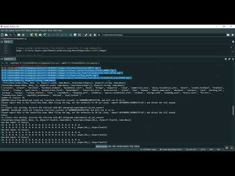
AI & ML Models
0.0 (0 reviews) • 0 downloads
Satellite Area Image Classification in Python Projects
र 1000
Satellite Area Image Classification in Python Projects
Technical Details
Domain : Python
Database : Sqlite
Tools : Anaconda
Run Tools: VS Code
Database : Sqlite
Tools : Anaconda
Run Tools: VS Code
Secure Payment
Instant Download
GST Invoice
24/7 Support
About This Product
Satellite Area Image Classification in Python Projects
Abstract
The Satellite Area Image Classification Project is a Python-based system designed to classify satellite images into different land cover or area types, such as urban, agricultural, forest, water bodies, and barren land. The system uses image processing and machine learning techniques, particularly Convolutional Neural Networks (CNNs), to automatically extract features from satellite imagery and perform accurate classification. Python libraries such as TensorFlow/Keras, OpenCV, NumPy, Pandas, and Matplotlib are utilized for image preprocessing, feature extraction, model training, and result visualization. This project assists in urban planning, environmental monitoring, disaster management, and agricultural assessment by providing automated, scalable, and precise classification of satellite imagery.
Existing System
Traditional satellite image classification relies on manual interpretation by experts or basic statistical techniques such as supervised or unsupervised classification (e.g., Maximum Likelihood Classification or K-Means clustering). These methods are time-consuming, require expert knowledge, and are often less accurate, especially for large-scale or high-resolution imagery. Existing automated approaches using simple machine learning models depend on handcrafted features, which may fail to capture complex patterns in multispectral or heterogeneous satellite images. As a result, these methods may produce misclassifications and cannot handle large datasets efficiently, limiting their effectiveness in real-world applications.
Proposed System
The proposed system integrates deep learning-based classification using CNNs to improve accuracy and efficiency in satellite image analysis. Satellite images are preprocessed through resizing, normalization, and noise reduction, and data augmentation techniques are applied to improve model generalization. The CNN model automatically learns hierarchical features from images, enabling robust classification of different land cover types. Python libraries such as OpenCV handle preprocessing, TensorFlow/Keras manage model training and inference, and Matplotlib visualizes classification results and accuracy metrics. This approach allows scalable, automated, and high-accuracy classification of satellite imagery, supporting applications in environmental monitoring, resource management, and urban planning.
Abstract
The Satellite Area Image Classification Project is a Python-based system designed to classify satellite images into different land cover or area types, such as urban, agricultural, forest, water bodies, and barren land. The system uses image processing and machine learning techniques, particularly Convolutional Neural Networks (CNNs), to automatically extract features from satellite imagery and perform accurate classification. Python libraries such as TensorFlow/Keras, OpenCV, NumPy, Pandas, and Matplotlib are utilized for image preprocessing, feature extraction, model training, and result visualization. This project assists in urban planning, environmental monitoring, disaster management, and agricultural assessment by providing automated, scalable, and precise classification of satellite imagery.
Existing System
Traditional satellite image classification relies on manual interpretation by experts or basic statistical techniques such as supervised or unsupervised classification (e.g., Maximum Likelihood Classification or K-Means clustering). These methods are time-consuming, require expert knowledge, and are often less accurate, especially for large-scale or high-resolution imagery. Existing automated approaches using simple machine learning models depend on handcrafted features, which may fail to capture complex patterns in multispectral or heterogeneous satellite images. As a result, these methods may produce misclassifications and cannot handle large datasets efficiently, limiting their effectiveness in real-world applications.
Proposed System
The proposed system integrates deep learning-based classification using CNNs to improve accuracy and efficiency in satellite image analysis. Satellite images are preprocessed through resizing, normalization, and noise reduction, and data augmentation techniques are applied to improve model generalization. The CNN model automatically learns hierarchical features from images, enabling robust classification of different land cover types. Python libraries such as OpenCV handle preprocessing, TensorFlow/Keras manage model training and inference, and Matplotlib visualizes classification results and accuracy metrics. This approach allows scalable, automated, and high-accuracy classification of satellite imagery, supporting applications in environmental monitoring, resource management, and urban planning.
Customer Reviews (0)
No reviews yet. Be the first!
Related Products
⭐ Featured

AI & ML Models
Zomato Restaurant Reviews Sentimental Analyzer in Python Projects
Zomato Restaurant Reviews Sentimental Analyzer in Python Projects
र 1000
⭐ Featured
⭐ Featured

AI & ML Models
Voice Disorder Prediction using Audio Dataset in Python Projects
Voice Disorder Prediction using Audio Dataset in Python Projects
र 1000

AI & ML Models
Vitamin Deficiency Detection Using Image Processing in Python Projects
Vitamin Deficiency Detection Using Image Processing in Python Projects
र 1000