AI & ML Models
0.0 (0 reviews) • 0 downloads
Hyper Spectral Image Classification Satellite Image in Python Projects
र 1000
Hyper Spectral Image Classification Satellite Image in Python Projects
Technical Details
Domain : Python
Database : Sqlite
Tools : Anaconda
Run Tools: VS Code
Database : Sqlite
Tools : Anaconda
Run Tools: VS Code
Secure Payment
Instant Download
GST Invoice
24/7 Support
About This Product
Hyper Spectral Image Classification Satellite Image in Python Projects
Abstract
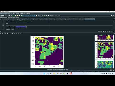
Hyperspectral imaging (HSI) captures rich spectral information across hundreds of contiguous bands, providing detailed insights for applications such as agriculture, environmental monitoring, and land-use classification. This project focuses on developing a Python-based Hyperspectral Image Classification system for satellite imagery. The system processes hyperspectral data to classify different land cover types, crop health, or environmental features by extracting both spectral and spatial information. Implemented using Python libraries such as TensorFlow/Keras, NumPy, Pandas, and scikit-learn, the model leverages Convolutional Neural Networks (CNN) or hybrid CNN-LSTM architectures to handle high-dimensional spectral data. The project enables accurate, automated classification of satellite images, facilitating decision-making in remote sensing and geospatial analysis.
Existing System
Traditional hyperspectral image classification relies on manual interpretation, spectral indices, or classical machine learning algorithms such as Support Vector Machines (SVM), Random Forests, or k-Nearest Neighbors (kNN). While these methods can achieve reasonable accuracy, they struggle with high-dimensional data, spectral redundancy, noise, and mixed pixels. Existing approaches often fail to incorporate spatial context effectively and are limited in handling large-scale satellite datasets efficiently. Manual preprocessing and feature selection are also time-consuming and may not generalize well across different geographic regions or sensor types.
Proposed System
The proposed system introduces a deep learning framework for hyperspectral image classification that combines spectral and spatial feature extraction. Input hyperspectral images are preprocessed using normalization, dimensionality reduction (e.g., PCA), and data augmentation to enhance model generalization. CNNs or hybrid CNN-LSTM models are trained to learn both local spatial patterns and spectral signatures for each pixel or image patch. Python libraries such as TensorFlow/Keras implement the neural networks, NumPy and Pandas handle preprocessing and dataset management, and scikit-learn supports evaluation metrics such as accuracy, precision, recall, and F1-score. The system can classify each pixel or region into land cover categories and visualize classification maps for easy interpretation. By combining advanced deep learning techniques with hyperspectral data, the system provides an accurate, scalable, and automated solution for satellite image analysis, supporting applications in environmental monitoring, agriculture, and urban planning.
Abstract
Hyperspectral imaging (HSI) captures rich spectral information across hundreds of contiguous bands, providing detailed insights for applications such as agriculture, environmental monitoring, and land-use classification. This project focuses on developing a Python-based Hyperspectral Image Classification system for satellite imagery. The system processes hyperspectral data to classify different land cover types, crop health, or environmental features by extracting both spectral and spatial information. Implemented using Python libraries such as TensorFlow/Keras, NumPy, Pandas, and scikit-learn, the model leverages Convolutional Neural Networks (CNN) or hybrid CNN-LSTM architectures to handle high-dimensional spectral data. The project enables accurate, automated classification of satellite images, facilitating decision-making in remote sensing and geospatial analysis.
Existing System
Traditional hyperspectral image classification relies on manual interpretation, spectral indices, or classical machine learning algorithms such as Support Vector Machines (SVM), Random Forests, or k-Nearest Neighbors (kNN). While these methods can achieve reasonable accuracy, they struggle with high-dimensional data, spectral redundancy, noise, and mixed pixels. Existing approaches often fail to incorporate spatial context effectively and are limited in handling large-scale satellite datasets efficiently. Manual preprocessing and feature selection are also time-consuming and may not generalize well across different geographic regions or sensor types.
Proposed System
The proposed system introduces a deep learning framework for hyperspectral image classification that combines spectral and spatial feature extraction. Input hyperspectral images are preprocessed using normalization, dimensionality reduction (e.g., PCA), and data augmentation to enhance model generalization. CNNs or hybrid CNN-LSTM models are trained to learn both local spatial patterns and spectral signatures for each pixel or image patch. Python libraries such as TensorFlow/Keras implement the neural networks, NumPy and Pandas handle preprocessing and dataset management, and scikit-learn supports evaluation metrics such as accuracy, precision, recall, and F1-score. The system can classify each pixel or region into land cover categories and visualize classification maps for easy interpretation. By combining advanced deep learning techniques with hyperspectral data, the system provides an accurate, scalable, and automated solution for satellite image analysis, supporting applications in environmental monitoring, agriculture, and urban planning.
Customer Reviews (0)
No reviews yet. Be the first!
Related Products
⭐ Featured

AI & ML Models
Zomato Restaurant Reviews Sentimental Analyzer in Python Projects
Zomato Restaurant Reviews Sentimental Analyzer in Python Projects
र 1000
⭐ Featured
⭐ Featured

AI & ML Models
Voice Disorder Prediction using Audio Dataset in Python Projects
Voice Disorder Prediction using Audio Dataset in Python Projects
र 1000

AI & ML Models
Vitamin Deficiency Detection Using Image Processing in Python Projects
Vitamin Deficiency Detection Using Image Processing in Python Projects
र 1000