AI & ML Models
0.0 (0 reviews) • 0 downloads
Building Footprint Extraction using Flash in Python Projects
र 1000
Building Footprint Extraction using Flash in Python Projects
Technical Details
Domain : Python
Database : Sqlite
Tools : Anaconda
Run Tools: VS Code
Database : Sqlite
Tools : Anaconda
Run Tools: VS Code
Secure Payment
Instant Download
GST Invoice
24/7 Support
About This Product
Building Footprint Extraction using Flash in Python Projects
Abstract
Building footprint extraction from satellite imagery is a critical process in urban planning, disaster management, land use monitoring, and geographic information systems (GIS). This project proposes an automated Building Footprint Extraction System using Flash and Python. The system integrates Microsoft FlashFill-like intelligent pattern learning techniques with deep learning segmentation models to detect and extract precise building boundaries from high-resolution remote sensing images. Python libraries such as PyTorch Lightning Flash (Flash), Torchvision, OpenCV, and Rasterio are utilized to simplify model training and streamline the deep learning workflow. Using Flash’s high-level API for image segmentation, the project enables rapid prototyping, training, and deployment with minimal code while delivering high accuracy. The automated building extraction system reduces manual mapping effort and enhances scalability and efficiency for real-world urban applications.
Existing System
Manual digitization and traditional edge-based image processing are widely used in current building footprint extraction workflows. However, these methods are time-consuming, labor-intensive, and highly error-prone in dense urban environments. Existing GIS tools also struggle to detect building edges in low-contrast regions or complex shadow areas. Moreover, earlier machine learning models rely on handcrafted features and lack generalization capabilities for different terrain and satellite image resolutions. Deep learning solutions exist, but they are complex to implement and require extensive code and GPU configuration, limiting accessibility for students and researchers.
Proposed System
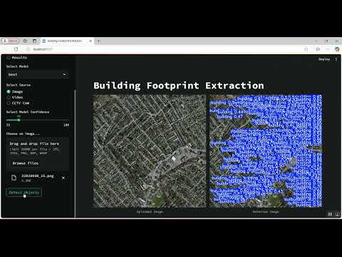
The proposed system leverages the PyTorch Lightning Flash framework to implement an end-to-end deep learning solution for automatic building extraction from satellite imagery. Flash simplifies image segmentation using its ImageSegmentation module with built-in backbones like ResNet, EfficientNet, and U-Net, enabling fast development with optimized training loops. Satellite images are preprocessed using OpenCV and Rasterio to enhance building edges and remove noise. A Flash-based U-Net model is trained on geospatial datasets like INRIA Aerial Image Dataset or SpaceNet Building Footprints. The extracted building masks are post-processed using morphological operations and contour detection and exported in GeoJSON or Shapefile format. A simple Streamlit GUI is also provided for user interaction, allowing users to upload satellite images and view detected building footprints instantly. The proposed system is accurate, fast to implement, and suitable for academic and industrial applications.
Abstract
Building footprint extraction from satellite imagery is a critical process in urban planning, disaster management, land use monitoring, and geographic information systems (GIS). This project proposes an automated Building Footprint Extraction System using Flash and Python. The system integrates Microsoft FlashFill-like intelligent pattern learning techniques with deep learning segmentation models to detect and extract precise building boundaries from high-resolution remote sensing images. Python libraries such as PyTorch Lightning Flash (Flash), Torchvision, OpenCV, and Rasterio are utilized to simplify model training and streamline the deep learning workflow. Using Flash’s high-level API for image segmentation, the project enables rapid prototyping, training, and deployment with minimal code while delivering high accuracy. The automated building extraction system reduces manual mapping effort and enhances scalability and efficiency for real-world urban applications.
Existing System
Manual digitization and traditional edge-based image processing are widely used in current building footprint extraction workflows. However, these methods are time-consuming, labor-intensive, and highly error-prone in dense urban environments. Existing GIS tools also struggle to detect building edges in low-contrast regions or complex shadow areas. Moreover, earlier machine learning models rely on handcrafted features and lack generalization capabilities for different terrain and satellite image resolutions. Deep learning solutions exist, but they are complex to implement and require extensive code and GPU configuration, limiting accessibility for students and researchers.
Proposed System
The proposed system leverages the PyTorch Lightning Flash framework to implement an end-to-end deep learning solution for automatic building extraction from satellite imagery. Flash simplifies image segmentation using its ImageSegmentation module with built-in backbones like ResNet, EfficientNet, and U-Net, enabling fast development with optimized training loops. Satellite images are preprocessed using OpenCV and Rasterio to enhance building edges and remove noise. A Flash-based U-Net model is trained on geospatial datasets like INRIA Aerial Image Dataset or SpaceNet Building Footprints. The extracted building masks are post-processed using morphological operations and contour detection and exported in GeoJSON or Shapefile format. A simple Streamlit GUI is also provided for user interaction, allowing users to upload satellite images and view detected building footprints instantly. The proposed system is accurate, fast to implement, and suitable for academic and industrial applications.
Customer Reviews (0)
No reviews yet. Be the first!
Related Products
⭐ Featured

AI & ML Models
Zomato Restaurant Reviews Sentimental Analyzer in Python Projects
Zomato Restaurant Reviews Sentimental Analyzer in Python Projects
र 1000
⭐ Featured
⭐ Featured

AI & ML Models
Voice Disorder Prediction using Audio Dataset in Python Projects
Voice Disorder Prediction using Audio Dataset in Python Projects
र 1000

AI & ML Models
Vitamin Deficiency Detection Using Image Processing in Python Projects
Vitamin Deficiency Detection Using Image Processing in Python Projects
र 1000